Newfoundland Memorial Park


Among the most impressive sites at the Somme, and along the whole Western Front, is the Newfoundland Memorial Park - land owned and preserved by Canada.  At the time, Newfoundland was part of the United Kingdom; it has since been incorporated into Canada.

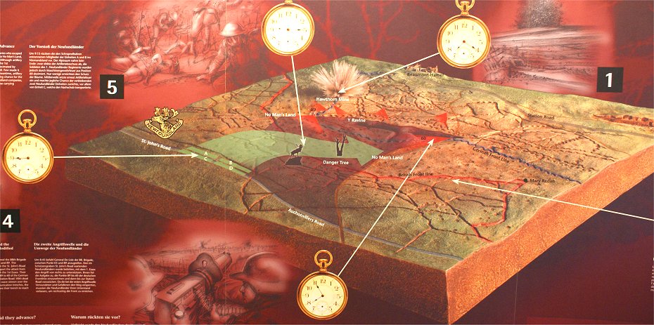
As we have already seen at 7:20, the Hawthorn Mine was blown and the bombardment switched to the German rear.  The infantry waited ten minutes after the explosion to advance, giving the Germans a head start on returning to their trenches and to prepare for the attack.  The attack was repulsed with heavy losses.  Afterward, at around 7:55, the Germans began bombarding the British trenches with artillery and hitting them with machine gun fire.

Although the attack had been an abject failure, as was the case in other sectors, there were reports of some success.  This may have spurred the divisional commander to renew the attack and commit the reserve.  So at around 8:45, the 88th Brigade was ordered to attack renew the attack with the 1st Newfoundland Regt supporting them on their right, with the 1st Essex Regt supporting further to the right.  

Both the Newfoundland Regiment and the 1st Essex were in a trenches to the rear.  The Essex regiment would move to the front line through the communications trenches, now clogged with the wounded from the first attack.  This took one or two hours to acomplish.  Despite this precaution, the 1st Essex took frightful casualties in a futile attack.  The commander of the Newfoundland Regiment had decided to avoid the clogged trenches to his front by going over the top and advancing over open ground.  It would be a costly decision.


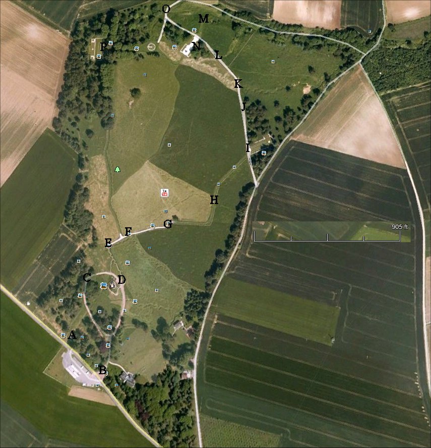
The letters correspond to the panoramas below.


A)  St. John's Road

The Newfoundland Regiment was in this support trench called St John's Road, named after the capital of Newfoundland.  Beyond the road at left is a parking area with markings showing the location of communication trenches. which you can see on the left of the panorama.


B) Park Entrance

This is a 180 degree view from the park entrance.  The support trenches that the Newfoundland men attacked from can be seen on either side.  A small museum building is at right.  We will continue along the path in the center, following the attack.  Just in front of the people you can see the memorial to the 29th Division.


C) Approaching Caribou Monument

Now we are approaching the Caribou monument, which you can see at right.


D) Caribou Monument


This is from in front of the Caribou monument.  On the right side of the panorama, a path leads into the trench system.  Before we continue that direction, first let's climb up to the monument.  The regiment's cap badge included a caribou.


This is the view looking east from the monument mound.  The trenches preserved in the park are a special treat as most Western Front trenches have been filled in to facilitate farming.


From atop the mound there is an excellent view of the ground ahead to the German line, which was near the 51st Highland Division monument, which commemorates their attack on November 13th.  For orientation, the Hawthorn Crater is between and behind the 51st Division monument and the Hawthorn Ridge No. 2 Cemetery, but it cannot be seen due to the trees.  Beaumont Hamel is about 1,000 yards behind the German front line.  Redan Ridge is beyond Beaumont Hamel - then Serre is further still but difficult to distinguish.  The British front line trench can be seen along the length of the panorama.


E) Exiting Communications Trench

After a short trip through a trench from the caribou, we emerge and will now walk along the path at left toward German lines.  Due to erosion, the trench has lost about two feet of depth.  The path branching off to the left from the main path parallels the British front line.  You can see the front line trench extending into the field in the center of the panorama.  Next we will continue along the path to the frontline trench.


F) British Front Line

Having walked along the path from the left, we are now at the British frontline trench, built by the British in July 1915 after they took over the sector from the French.  It was 300 yards that the Newfoundland men endured to reach the frontline trenches, then they had to pass through the gaps in their own barbed wire and proceed another 300 yards to reach the German barbed wire.  They had already suffered horribly  just reaching the front line, but they continued on.  We will follow them, continuing along the path to the left toward German lines.


G) Danger Tree

We are now in no man's land near the Danger Tree, now represented in stone.  The attackers took note of a tree here and tended to move toward it as the attack bogged down.  Many of the casualties suffered by the Newfoundland Regiment were in this area.  Next will continue toward Y-Ravine Cemetery then continue to German lines.


H) Wellington Trench

Before the attacks of July 1st, it was planned to advance the trenches to this point to lessen the distance that the attackers would have to cross.  Time ran out, and the project was not completed.  North Alley connected Wellington Trench with the former front line.  Only after the failed attacks was Wellington Trench dug, and it was from here that the Highlanders successfully launched their attack in November.  Note what could be shell craters or collapsed dugouts on the left side of the panorama.


I) Y-Ravine Cemetery

After this area was finally captured in November, burials began here at Y-Ravine cemetery for many of the men who had died in no man's land on July 1st and whose bodies had not been recovered.


J) No Man's Land

Continuing along the road, the German frontline trench is now in sight.  If you will note, we are now on the physical crest of the ridge.  The German front line on the left of the panorama is actually on the reverse slope.


K) German Front Line Trench

In this 360 degree view we have reached the German front line.  Y-Ravine in the German rear is now in view.  As we saw in the previous panorama the German front line is on the reverse slope so the field of fire to the front is limited.  If you look down the road in the center of the panorama - toward the British - you can see the road reach a crest.  The area beyond this crest is dead ground which cannot be fired on from here.  To make up for this deficiency, the Germans dug tunnels forward to sentry posts overlooking the low ground, and they made liberal use of barbed wire in this area.  This dead ground could, however, be reached by Germans firing from the ridges behind the German front line.  This ride can be seen behind the Y Ravine.


L) Y-Ravine Trench

Continuing along the road we come to a branch ravine of Y-Ravine. (thusly the shape and name of Y Ravine)  The Germans used this ravine to approach the front lines in safety and dug entrances to dugouts from the ravine.


M) Y-Ravine

Continuing along we can now see the main branch of Y Ravine.  German troops used the ravine to reach the front lines here in relative safety from rear areas near Beaumont Hamel.  The German also had dugouts along the length of the ravine.


N) 51st Highland Division Memorial


On November 13th the Highlanders finally captured the area, including the village of Beaumont Hamel.  Behind the Highland Division Memorial, the German trenches pivot back.


O) Y-Ravine

In this 180 degree view we see the end of the ravine.  The Highland Division monument is visible in the trees at center.  The trenches visible on the right are pivoting to the rear - nearly 90 degrees - and extended outside the confines of Newfoundland Park to Hawthorn Crater.


P) Hawthorn Ridge No. 2 Cemetery

The Highland Division monument can be seen down the path on the left of the panorama.  The Hunter's Cemetery nearby was made in a shell crater.  It is here that the German trench line pivots to the rear.  Before walking back to the park entrance, we see the Hawthorn Ridge No. 2 Cemetery, which contains many killed from July 1st.

The 1st Newfoundland Regiment started with 780 men attacking and lost 26 officers and 658 men.


Copyright 2012 by John Hamill


Back to the Somme