The Third Line - The New Interpretation

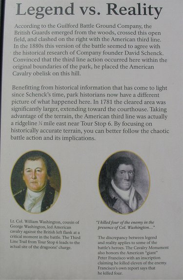
This park service sign near the Peter Francisco monument is the only explanation given for the new interpretation. E-mail discussions with several well informed people and a one on one discussion with park ranger Donald Long during my most recent visit have largely removed my skepticism concerning the change. Please see also - Cultural Landscape Report From Guilford CH NPS website.
The "new" location of the third line was determined around twenty years ago, but the powers that be weren't open to the new interpretation and passed up opportunities to buy battlefield land which has since been lost to development. A recent park employee, Tom Baker, researched the issue thoroughly but died before publishing the findings. Although it has not been widely publicized, the current park administration decided to go ahead and make the necessary changes. So far there have been few books published incorporating the new interpretation.
As stated on the park service sign, the current third line was not within the original boundaries of the Guilford Battleground Company property. As implied, but not specifically stated, this influenced the founder's determination that the third line was at the "old" location. The sword of Lt. Col. Stuart was found at the "old line", giving credence to the story, but strangely, the sword was found wrapped up and inside a hollow log. Obviously it had been handled sometime after Stuart's death.
The original Cornwallis map is a major piece of evidence. (Click here, then click on the map for the similar Tarleton map.) Unfortunately the map does not show stream locations, which would have solved the whole issue, but it does provide important clues. On the map, the courthouse is close behind the American line. Participant accounts of the battle state that the battle at the third line was near the courthouse. The old third line is 1/4 mile from the courthouse! The map also shows two hollows extending up the third line ridge. Looking on a topo map (enable javascript), you can see what appears to be the two hollows. On the Cornwallis map, the ridge on the British left is higher than the section closer to the center. The topo map also shows this. Barely visible on the old map is the hill where the British artillery was positioned. This is near the end of the American counterattack line on the map. The topo map shows a hill here. This is the modern location of the Peter Francisco monument. Unfired British cannonballs have been found on top of the hill, confirming that it was the position of the British artillery which during the final stages of the battle fired into friend and foe alike.
The outline of the New Garden Road near the old third line does match the contemporary map, but the exact route of the road was unknown, and the road in the park is a reconstruction based on the old interpretation. Recently, ground-penetrating radar has largely cleared this question up, showing that with some exceptions, the interpreted route is within a few feet of the original.
British accounts mention crossing a ravine on the way to the American third line. This could be the area of the "old" third line battlefield which resembles a ravine more than it does a ridge. In addition, the new third line ridge is fronted by a stream and is a much better position for defense. It supposedly protects against British approach on a recently discovered road from the south. I do not know its location, but it could be the present day road which connects the national park to the Greensboro park or somewhere near here.
Looking on the Cornwallis or Tarleton map, it is puzzling why Greene positioned his third line entirely on the north side of the road since the "old" third line could easily be flanked to the south. The current interpretation of the battle shows Greene was more concerned with his northern, or right flank. If you move the third line back to its new position, the reason become more clear. On the topo map, the area east of "Francisco Hill," has a very steep slope. This rough terrain would be a major obstacle to a British advance here. This would protect the American left and therefore provide an excellent argument for the "new" third line.
To the best of my limited knowledge, archeologists with metal detectors have not found musket balls or other such things in the area of the new third line. Regardless, there are a number of points in favor of the new interpretation. Looked at individually, they could be explained away, but taken together as a whole they are a powerful argument in favor of the new interpretation.
Acknowledgements
I am grateful for the assistance of Ray Cassel, Ken Skinner, and Groggydice@aol who, through e-mail, provided me with the basic arguments in favor of the new interpretation. Please see Groggydice's e-mail. I am also indebted to the very knowledgeable Donald Long of the park service who answered my questions during my most recent visit and fleshed out the arguments for the new interpretation. Information has also been gathered from the above mentioned Cultural Landscape Report. Any errors, of course, are entirely mine and are very likely.