Dover Castle
Dover has been inhabited and fortified for centuries as it is a port at the narrowest section of the English Channel. Iron Age defenses were built over by the Romans, who constructed a lighthouse. On his way to London in 1066, William the Conqueror had a castle built here, and his descendant Henry II expanded upon it in the late 1100s. Modifications were made after vulnerabilities were revealed in the 1216 siege by the French. Georgian military engineers modified the works in from the mid 1700s to the early 1800s to deal with gunpowder weaponry, and extensive tunnels were dug under the castle in the 20th century to protect command facilities from aerial and nuclear attack. So Dover Castle has a delightful variety of military architecture. Let's take a look!

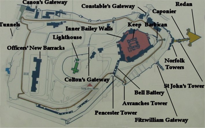
Modified Map of the Castle
This is a map on display which I have modified to show the points I will highlight. It should prove very useful. The redan is pointing generally northward, or inland.

View From the Northern End
From just outside the northern tip of the castle you can get a good view of its defenses. The Keep was the inner-most defensive structure designed for last ditch efforts, but it was also used as an occasional royal residence and for other purposes later. It was surrounded by the Inner Bailey Walls which were surrounded by the outer walls, of which the Constable's Gate is a part. Georgian engineers added the Redan in front of the lowered outer walls near the Norfolk Towers. In response to the 1940 invasion threat, concrete anti-tank obstacles were installed.

From East of Norfolk Towers
On the left of the picture you can see the Inner Bailey Walls and the never completed Barbican which protected the King's Gateway which passed through the walls. In the center you can see the Norfolk Towers section of the outer walls. The outer walls bend back here and were vulnerable as a result. In 1216, a French siege targeted this area with mining, which was then a gate area with high ground to its front. Afterwards underground tunnels connected the walls to a new structure beyond, St. John's Tower (not visible here), and the gate was replaced by the Constable's Gate visible in the previous picture and the Fitzwilliam Gate directly behind the cameraman.
From the mid 1700s to early 1800s, this area was again modified to protect against more modern siege methods. Both the inner bailey walls and the outer walls were reduced in height and the outer walls were thickened with earth. The redan was constructed and connected with a caponier.
Back to Index
Continue to Part 2