Fisher's Hill
September 22, 1864
After the battle of Cold Harbor in June 1864, Lee dispatched Jubal Early's Corps to Lynchburg to throw back Hunter's raid. After accomplishing this, Early advanced down the Shenandoah Valley and into Maryland. After a clash at Monocacy, Washington was even threatened, but Union reinforcements prevented its capture. Early withdrew to the Valley and raised hell as far north as Pennsylvania. In August 1864, Gen. Sheridan was appointed commander of the forces facing Early. Early could not decisively defeat Sheridan so Lee ordered Early to send Kershaw's division and an artillery battalion to Petersburg. On September 19th, Sheridan took advantage of Early's weakened army and attacked and defeated him at the Third Battle of Winchester. Early withdrew to an imposing fortified position at Fisher's Hill south of Strasburg. Protecting Early's left was Little North Mountain, and on his right was the North Branch of the Shenandoah River as well as the north end of Massanutten Mountain, or Three Top, which was a Confederate signal station. The Luray Valley to the east of Massanutten was protected by Wickam's cavalry, which prevented Early's whole position from being flanked. Unfortunately, this weakened Early's position on Fisher's Hill.
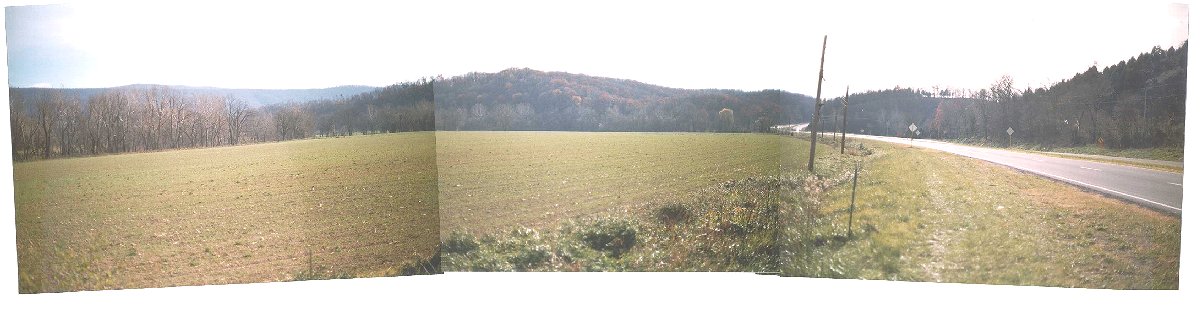
From the Valley Pike to Wharton's Position
Had Sheridan approached along the Valley Pike toward the eastern end of the Confederate line, this is what he would have seen. A formidable Confederate position on the ridge in front was difficult enough, but steep hills to the right if occupied by the enemy could prove disastrous to attackers. The Shenandoah River visible as the tree-line in the left middle-ground hampered any flanking move which would be confined by the Massanutten Mountain in the distance and which would then have to recross the river. Clearly this was not an ideal place to attack.
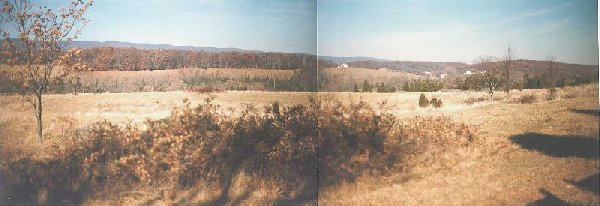
View From the Gordon's Position
This photo was taken on the right-center of the Confederate position, held by Gordon's division, looking toward the center and left of the Confederate position. The Manassas Gap Railroad passes through the small valley ahead. The next wooded hill was held by Pegram's division. Ramsuer's division was the left flank of the infantry, followed by Lomax's cavalry. The blue mountain three miles distant is Little North Mountain where Crook's corps would march for their flank attack. The wooded hill on the right was occupied by the Union XIX Corps to divert Confederate attention.
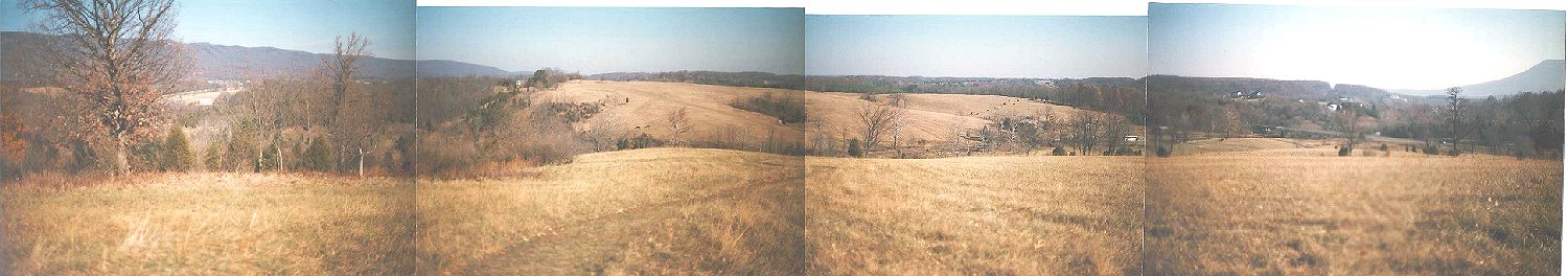
From Ramsuer's Hill
Early was especially weak on his left near Little North Mountain. Gen Crook commanding the VIII Corps of Sheridan's army suggested a flanking of the Confederate position by marching his corps down a trail on the side of Little North Mountain. These Union troop movements were concealed by rough terrain and darkness. The rest of the Union force diverted Confederate attention by advancing directly on Fisher's Hill. At 4 P.M. on September 22, 1864, Crook's corps launched its attack down the mountain onto Lomax's Confederate cavalry. The shock was too much for the Confederates. Panic spread down the Confederate line, and soon Early's whole army was in flight.
This is the spectacular view from Ramsuer's position on the far left of the Confederate infantry line. This property was purchased with private donations by the predecessor to the CWPT. On the far right is Three Top, or Massanutten Mountain, site of the Confederate signal station. The wooded hill visible to the left of Massanutten is the hill occupied by the XIX Corps visible in the previous picture. The cleared hill directly ahead was occupied by Rickett's Union division, which attacked Ramsuer's Hill and joined Crook's corps as it routed the Confederates. Crook's corps had marched along the side of Little North Mountain on the left of the picture and attacked Lomax's cavalry in the valley between this hill and the mountain. Lomax's cavalry broke, and survivors fled through Ramsuer's infantry on this hill. A new line was formed on this hill to face the attackers, but panic soon ensued, and the whole Confederate army fled towards Harrisonburg. The large tree on the left was there during the battle.
Early's army sustained 1,200 casualties, of whom 1,000 were captured, while Sheridan's army lost 500 men. The retreat ended only at Harrisonburg, about 40 miles away. Sheridan had ordered his cavalry to advance up Luray Valley and cut off the Confederates at New Market. The cavalry failed to do this, and when Early took up a strong position on the Blue Ridge, Sheridan withdrew back north of Strasburg, burning the barns, crops, mills, and industry of the Valley as he went. On October 19th, Early would strike the Union army at Cedar Creek.
topo map The "From the Valley Pike to Wharton's Position" photo was taken from Route 11 west of the words, "Sandy Hook," and looks south. The photo, "View From the Gordon's Position" was taken looking west from Route 11 near the letters "BM 748." The Emmanuel Church on the map is visible on the right of the picture. Ramsuer's Hill is west of the interstate south of Route 601.