J) View From Saddle Connecting Mount Joy and Its Spur
K) Original Earthworks on Mount Joy
Inner Defenses Area
While the outer defenses faced generally south, the inner defenses on the western end of the camp faced east toward the center of the camp. If the outer line had been captured, or if the British had entered the camp from the north by crossing the Schuylkill River, the American army would have fallen back to the inner defenses.
The inner defensive line ran from Mount Joy near the outer line north to a spur which connected to an east-west ridge on the the north end of the camp which rose above the Schuylkill. We will generally follow the tour route along the Mount Joy ridge and see some of the remains of the inner defense line, some of its outworks, and some of the army's hut locations.
|
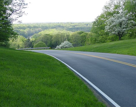
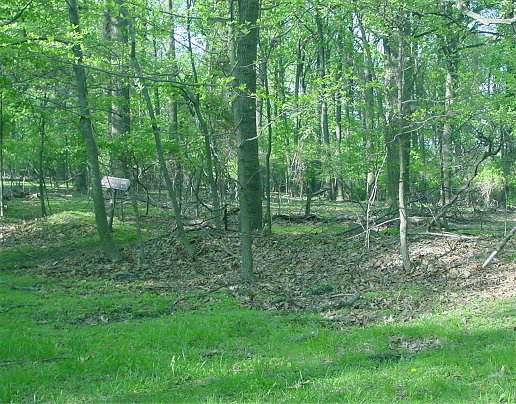
J) View From Saddle Connecting Mount Joy and Its Spur |
K) Original Earthworks on Mount Joy |
The picture on the left is the view from where Gulph Road crosses the saddle between Mount Joy and its spur. The view is looking west down to the Schuylkill River just beyond the vicinity of Washington's headquarters. The right picture shows original earthworks of the inner defensive line on Mount Joy. They survived because the area was unsuitable for farming or grazing. At it height, Mount Joy rises over 340 feet above the Schuylkill, around 200 feet higher than the eastern end of the outer defensive line, and nearly 300 feet above the lowest point on the Grand Parade.
L) Redoubt 3
Redoubt 3, or Fort Washington, is in front of the inner defensive line on the southern part of Mount Joy. Specifically, it is where the line pivots to the southwest to protect the flank. After a short gap or hollow there is the western end of the outer defensive line occupied by Wayne. So this redoubt could provide flanking fire for the inner defense line and perhaps more importantly help defend the flank of the outer line. Visible through the woods above the redoubt is the wooded hill Wayne camped on. Since there were no trees at the time, the view and field of fire was unobscured. The earthwork is a partial reconstruction.

M) From Artillery Park Looking East
This is the view from near the location of Knox's artillery park - north of Redoubt 3 and at the foot of the ridge. In theory if the encampment were attacked, the guns would be rushed from here to the threatened area. The historic road trace is just in front of the encampment and can be seen as a straight line of trees. On the left of the picture, the area to the right of the white car was the location of Maxwell's brigade. In the center of the picture you can see a line of trees marking the Gulph Road as it goes up the ridge of the outer defensive line which it crosses at the National Memorial Arch visible as the white rectangle separating two clumps of trees. The huts to the right of it are in the vicinity of Poor's brigade, to the right of which was Wayne's Pennsylvanian division.
Back to Valley Forge Home Page